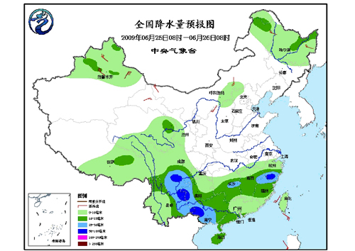
Forecast for Rainfall and Tropical Storm Nangka
Adjust font size:
In the next three days there will be light to moderate rain or shower to affect central and eastern Tibet Plateau, Yangtze-Hanshui River valley, south of the Yangtze, and most parts of southwest China. Heavy rain or torrential rain with severe convection is expected to hit central-southern Sichuan, eastern Yunnan, western Guangxi, coastal south China and Taiwan.

It is going to be mainly showery today in northern northeast China. An obvious precipitation process is expected to affect north China and northeast China from June 26.
The No. 4 tropical storm in this year Nangka has entered eastern South China Sea with maximum wind force up to 8 (20m/s). It is forecasted to move northwest at speed of 20 km per hour with gaining intensity.
On today, affected by it there will be strong wind with force scale up to 7 to 8 in eastern South China Sea. The areas that its center passes will be hit by gale up to scale 9 to 10.
On June 26 to 27 eastern central-northern South China Sea will be affected by strong wind up to 7 to 9. The areas that the center passes will be hit by gale to scale 10.
(Central Meteorological Office June 25, 2009)